After a toasty November and start to December across much of the Northeast, winter will make a grand appearance this week in the form of a major winter storm.
All eyes are on a powerful storm system that's set to develop into a nor'easter by Wednesday. This storm will likely lead to a significant snow event for parts of the Northeast and Mid-Atlantic Wednesday into Thursday.
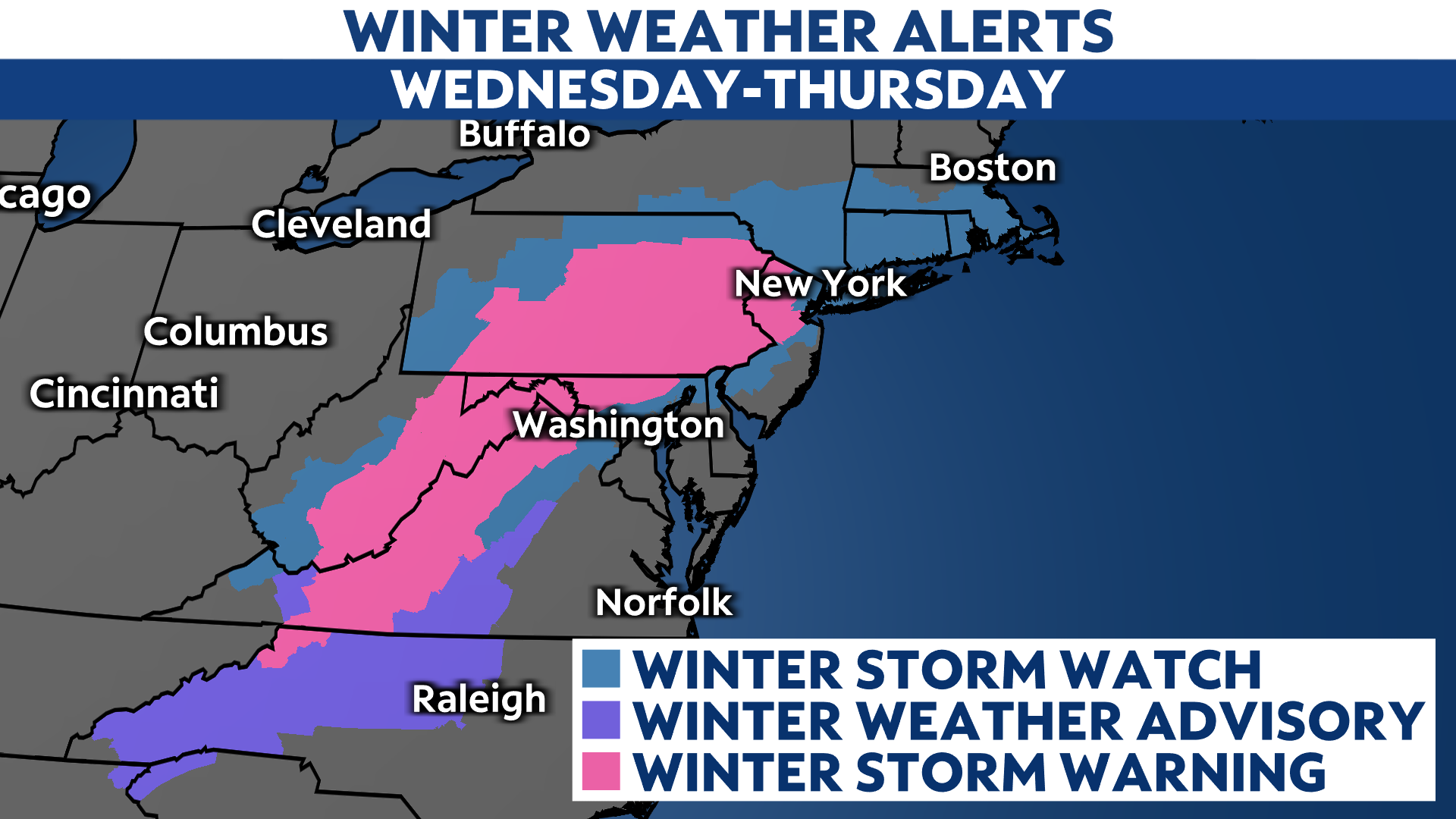
Winter storm watches were issued for parts of New York, including NYC and the tri-state region, late Monday afternoon. Early snow totals call for as much as 8-14 inches to fall in the city, which would make it the city's largest snowfall in nearly five years.
Watches are also in effect for the Hudson Valley and Southern Tier. Snowfall totals will range from 12-18" in the lower Hudson Valley to 8-12" farther north toward the Catskills. The Southern Tier can expect 6-12".
Winter storm warnings are already in place from New Jersey through western Virginia.

But there is also an amount of uncertainty with the storm's potential impact in any particular place.
A storm system moving across the Southern Plains on Tuesday moves east. By Wednesday, that system develops into a strong area of low pressure - buoyed in part by the temperature clash between the cold land mass and the mild sea-surface temperatures of the Atlantic Ocean. That cold air will set the stage for a hefty snow event for parts of the Northeast.
Since the system is still developing, here's what you should know: there will be a significant winter storm for much of the Northeast on Wednesday and Thursday, with the heaviest snow falling Wednesday night.
The exact details, though, are far from certain.
If the storm hugs the coast too much, it would lead to the heaviest snow falling farther inland.
If it passes too far offshore, then the system could miss many areas altogether and batter the open Atlantic Ocean with heavy snow and wind instead.

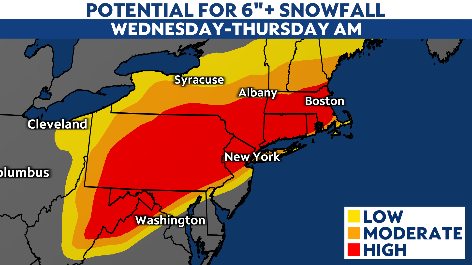
The most likely scenario is somewhere in between. As of Tuesday morning, these are the odds of getting at least six inches of snow. Some locations will pick up more than a foot, but where that happens depends on a number of factors.

A small shift in the track could have big implications on how much snow falls in any particular place.
On the week before Christmas, it only feels fitting to quote Lloyd Christmas: "So you're telling me there's a chance?"
Parts of southern New York and Massachusetts could see a lot of snow this week. Emphasis on "could."
The main question still hanging in the balance with this system is where exactly it tracks. A difference of, say, 50 miles could mean the difference between a bunch of snow or nothing to write home about.
The other big question looks to be how quickly it moves. This particular storm moves to the east pretty quickly, based on the latest computer forecast model guidance.
If it moves too fast, it could reduce snowfall amounts and steer the majority of the heaviest snow out to sea. But if it slows down just enough (this is probably closest to the current thinking), it could lead to a four-to-six hour period of very heavy snow for the big cities Wednesday evening or overnight.
From a broader standpoint and in the words of other Spectrum News meteorologists, forecasting snowfall is the hardest thing we do. Predicting the future is difficult, even with the world's most powerful computers dedicated to the cause.
If you browse Facebook or other social media platforms this weekend, you may see some exaggerated or straight-up wild forecasts. Here's a guide on what to look for in determining whether or not a weather-related social media post is accurate.
But as always, keep it with Spectrum News and NY1 for the latest, most accurate and hype-free forecast.


