


TAMPA, Fla. — The National Hurricane Center released its final report on Hurricane Milton. Here are the final numbers from around Tampa Bay.
What You Need To Know
- Milton was one of the strongest hurricanes on record in the Atlantic basin
- It had peak winds of 180 mph
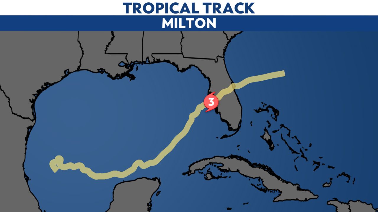
- Milton made landfall near Siesta Key on Oct. 9, 2024
- More than 20 inches of rain fell in St. Petersburg
- More Hurricane Milton stories
MILTON STATS
Milton was one of the strongest hurricanes on record in the Atlantic basin, reaching Category 5 intensity in the Gulf on Oct. 7, 2024 with peak winds 180 mph (155 kts).
The pressure is estimated to have been 895 mb at the time of peak intensity. This ties Hurricane Rita of 2005 for the fourth-lowest minimum central pressure in the Atlantic basin. The lower central pressures include 882 mb in Wilma in 2005, 888 mb in Gilbert in 1988 and 892 mb in the Labor Day Hurricane of 1935.
Milton made landfall near Siesta Key on Oct. 9, 2024 at 8:30 p.m. as a Category 3 hurricane with max winds of 115 mph.

The NOAA National Centers for Environmental Information (NCEI) estimates that Milton caused $34.3 billion in damage in the United States, almost exclusively in Florida.
One prominent building damaged by the hurricane was Tropicana Field, where the fabric roof was ripped off by high winds followed by water damage from rain falling into the stadium.
The report notes that the west coast most affected by Hurricane Milton had also been affected by Hurricane Helene two weeks before, which complicated damage assessments.
In Florida, Milton caused hurricane conditions along the west coast from Clearwater Beach and Tampa southward across Sarasota to near Venice. Tropical storm conditions occurred elsewhere across the Florida Peninsula south of a Cedar Key - Fernandina Beach line, with hurricane-force wind gusts reported in central Florida near the track of the center.
STORM SURGE
Here are the storm surge numbers from Florida's Gulf Coast.
- 4-6 ft from Longboat key to Venice and near landfall location.
- 1-2 feet Tampa Bay (a sharp gradient in the surge occurred north of the landfall location where the winds were mostly offshore)
- 4–6 ft south of Boca Grande through Bonita Beach.
- 5–8 ft in the northern portion of Charlotte Harbor and along the Peace River.
- 6–9 ft from Venice southward to Boca Grande
- An isolated peak of up to 10 ft estimated near Manasota Key, excluding the height of waves.
There were destructive storm surge impacts to the Manasota Key beach front community and significant coastal erosion. A new inlet was opened termed Milton Pass. Survey crews concluded that the water was moving extremely fast and the wave action was tremendous, leading to 'blowout' of the first floor of many structures.
The report notes that the same area had a significant storm surge from Hurricane Helene two weeks prior, and the erosion and debris from its aftermath compounded the damages incurred during Milton.
WINDS
Here are the top wind reports from Milton that were recorded over water:
- Egmont Key 86/105 mph
- Skyway Fishing Pier 73/102 mph
- Sarasota-Bradenton Airport 69/102 mph
- Middle Tampa Bay 74/98 mph
- Egmont Channel 78/100 mph
Here are the top wind reports from each county around Tampa Bay:
- Manatee County: Peak wind gusts 80 to 100 mph, Sarasota-Bradenton Airport 102 mph wind gust
- Pinellas County: Peak wind gusts 80 to 100 mph, St. Petersburg Albert Whitted Airport 101 mph wind gust
- Hillsborough County: Peak wind gusts 80 to 100 mph, Tampa Airport 93 mph wind gust
- Polk County: Peak wind gusts 80 to 90 mph, Winter Haven Airport 87 mph wind gust
- Pasco County: Peak wind gusts 65 to 75 mph, Zephyrhills 59 mph wind gust
- Hernando County: Peak wind gusts 60 to 70 mph, Brooksville 76 mph wind gust
- Citrus County: Peak wind gusts 50 to 60 mph., Inverness 58 mph wind gust
RAINFALL AND FLOODING
Milton produced a large area of heavy rain across portions of the central and northern Florida Peninsula, including 10 to 20 inches of rain in Tampa Bay.
The highest reported storm total rainfall was 20.40 inches at a Community Collaborative Rain, Hail and Snow Network (CoCoRaHS) site near St. Petersburg.
Here's a collection of rainfall reports from the airports, CoCoRaHS, and other sites:
- 20.40” St. Petersburg
- 18.88” St. Petersburg Albert Whitted Airport
- 18.82” near Westchase
- 16.88” Largo
- 15.66” Temple Terrace
- 15.03” Pinellas Park
- 14.94” Dade City
- 14.15” Trilby
- 14.73” Dover
- 14.13” Zephyrhills
- 13.68” Oldsmar
- 13.62” Thonotosassa
- 13.13” Lakeland Airport
- 13.05” Plant City
- 13.05” Bradenton
- 12.78” Gulfport
- 12.52” Clearwater
- 12.32” Citrus Park
- 11.91” Riverview
- 11.73” Tampa Airport
- 11.63” Safety Harbor
- 11.40” Wesley Chapel
- 11.10” Tarpon Springs
- 10.44” Ruskin
- 10.28” Auburndale
- 9.67” Lithia
- 9.46” Spring Hill
- 9.07” Weeki Wachee
- 9.02” Elfers
- 8.15” Myakka Head
- 7.74” Floral City
- 7.58” Sarasota/Bradenton Airport
- 7.51” Homosassa
- 7.47” Wimauma
- 7.31” New Port Richey
- 7.17” Inverness
- 6.49” Brooksville Airport
- 6.48” Lecanto
- 4.77” Holder
- 4.60 Winter Haven Airport
Here's an interactive rainfall map from around Florida.
These rains caused widespread river and urban flooding, particularly in Tampa Bay with record-high crests on the Hillsborough River: a crest of 38.16 feet at Morris Bridge on Oct. 12 and 17.14 feet near Zephyrhills at Hillsborough River State Park on Oct. 10.
TORNADOES
Milton caused a significant tornado outbreak over the southern and central portions of the Florida Peninsula on Oct. 9.
- Milton caused a significant tornado outbreak over the southern and central portions of the Florida Peninsula on Oct. 9
- 45 known tornadoes on land and a tornadic waterspout over Lake Okeechobee
- The outbreak included 3 EF3 tornadoes, 6 EF2 tornadoes, 25 EF1 tornadoes, 7 EF0 tornadoes and 4 tornadoes of unknown intensity.
- One of the EF3 tornadoes killed six people near Fort Pierce and Vero Beach.
- There were 14 known injuries associated with the tornadoes.
Here is an interactive map of the tornadoes produced by Hurricane Milton.
IMPACTS
Milton is currently known to be responsible for 15 direct deaths – 12 in the United States (all in Florida) and 3 in Mexico.
- Six people died due to the tornado near Fort Pierce and Vero Beach.
- Four people were killed by falling trees, while there were two deaths due to freshwater flooding.
Milton caused 27 indirect deaths in the United States, all in Florida.
Most of the deaths were due to health issues during storm preparations or post-storm clean-up or due to falls related to storm preparations, clean-up, or power failures.
Our team of meteorologists dives deep into the science of weather and breaks down timely weather data and information. To view more weather and climate stories, check out our weather blogs section.