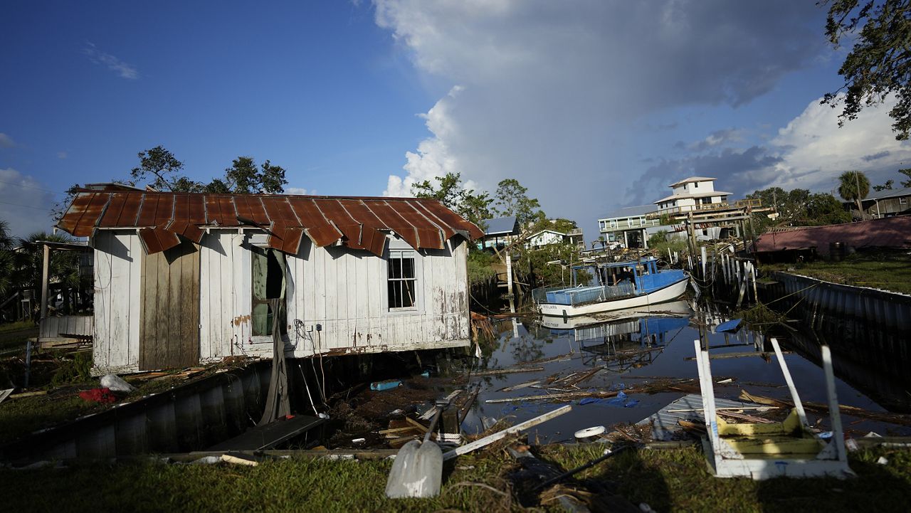
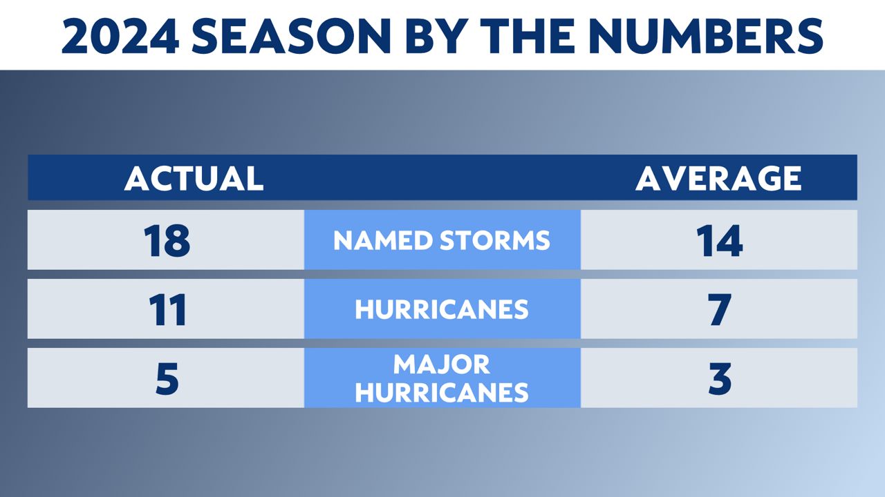
Today is the last day of the 2024 Atlantic hurricane season. Activity was above normal this year and there were five U.S. landfalls.
There were 18 named storms, 11 hurricanes and 5 major hurricanes this year. All of those numbers are above normal for the Atlantic basin.
Five hurricanes made landfall in the U.S., and two of them were major hurricanes. All the U.S. hurricane landfalls were on the Gulf Coast.
- Beryl, Category 1: July 8
- Debby, Category 1: Aug. 5
- Francine, Category 2: Sept. 11
- Helene, Category 4: Sept. 26
- Milton, Category 3: Oct. 9
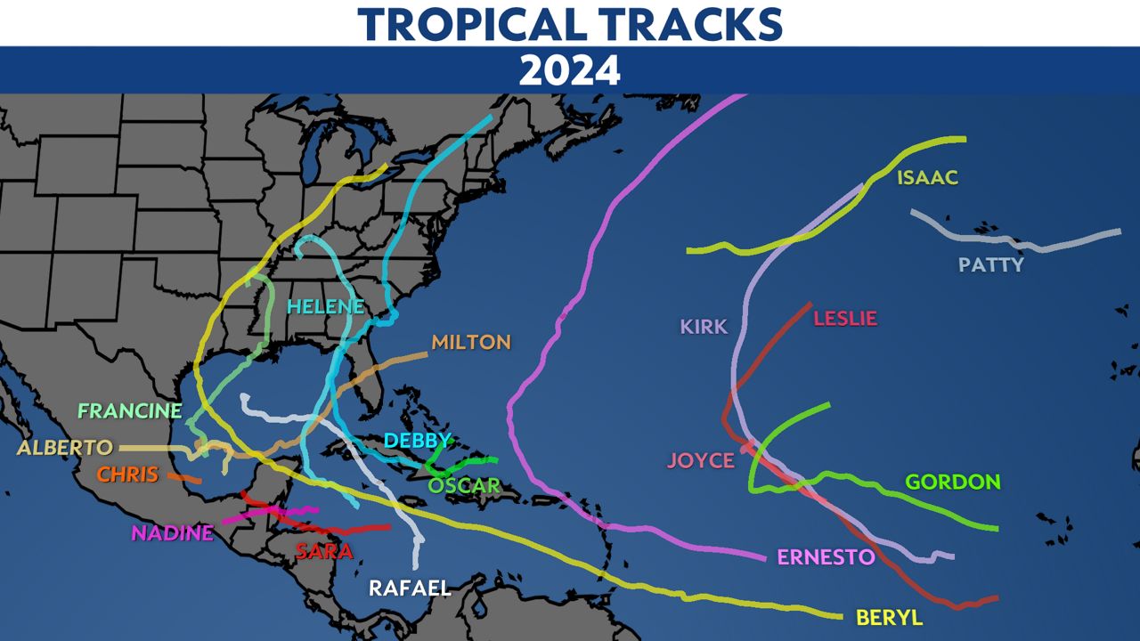
Both major hurricane landfalls were in Florida. Here are all the tropical tracks from this season.
The list of names used in 2024, excluding any names that get retired, will be re-used in 2030. It's likely that a few of the names will be retired from the list.
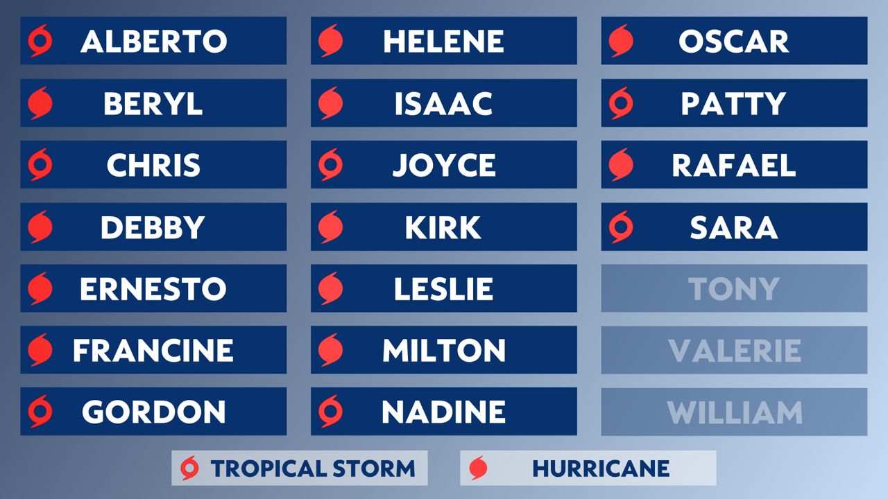
You can learn more about 2024's list of names here.
Alberto was the first named storm of the 2024 Atlantic hurricane season. It formed in the western Gulf of Mexico on June 19, becoming a tropical storm.
It made landfall in northeastern Mexico on June 20 with max winds of 45 mph, bringing heavy rain, coastal flooding and wind impacts to northern Mexico and South Texas. It dissipated quickly later that day.
Beryl was an early season, record-breaking storm that made three landfalls and strengthened into the earliest Category 5 storm in the Atlantic on record during its lifespan.
Beryl formed on Friday, June 28, becoming the second named storm of the year. It first became a hurricane on Saturday, June 29, and on Sunday, June 30, it became the earliest Atlantic Category 4 storm on record.
It was the earliest major hurricane (Category 3+) to form in the Atlantic basin since 1966, and the third earliest major hurricane to form on record.
It made its first of three landfalls on Carriacou Island in Grenada on Monday, July 1, as a strong Category 4 with max winds of 150 mph. It was the earliest Category 4 storm to make landfall in the Atlantic basin on record.
Beryl moved back over the southeastern Caribbean Sea and continued to strengthen into a Category 5 hurricane. It became the earliest Category 5 hurricane on record, breaking the prior record held by Hurricane Emily in 2005 by two weeks. Beryl was also the strongest July Atlantic hurricane on record.
It brushed past the south of Hispaniola, Jamaica and the Cayman Islands as a major hurricane before making its second landfall just northeast of Tulum on the Yucatan Peninsula in Mexico. It moved inland on the morning of July 5, as a Category 2 hurricane with max winds of 110 mph.
Its third and final landfall was near Matagorda, Texas, on July 8, as a Category 1 hurricane with max winds of 80 mph.
Chris formed on late Sunday, June 30, becoming the third named storm of the season. It made landfall near Lechuguillas in the Mexican state of Veracruz early in the morning on Monday, July 1, bringing heavy rainfall to eastern Mexico.
It was short-lived, dissipating shortly after making landfall and just over 12 hours after becoming a named storm.
Debby was the fourth named storm and the second hurricane to make landfall during 2024 Atlantic hurricane season. It made two landfalls and brought heavy rainfall, widespread flooding and severe weather across the eastern U.S.
It formed into a tropical storm on Saturday, Aug. 3 after moving into the Gulf of Mexico, and became a hurricane on Sunday, Aug. 4. Debby was the fourth named storm of the 2024 Atlantic hurricane season.
The storm moved north across the eastern Gulf of Mexico, bringing heavy rain and flooding to Florida’s Gulf Coast, eventually making landfall near Steinhatchee, Fla., early on Monday, Aug. 5 as a Category 1 hurricane.
Debby slowly pushed inland across north Florida and southern Georgia, weakening back into a tropical storm before pushing offshore into the western Atlantic.
The storm stayed off the coast of South Carolina for over a day as it slowly moved under weak steering currents. While sitting offshore, it brought flooding rainfall to the coastal southeast and strong winds to the coast, from Georgia across the Carolinas.
Tropical Storm Debby made a second landfall early on the morning of Thursday, Aug. 8, near Bulls Bay, S.C.
Rainfall totals in Georgia and the Carolinas piled up as Debby slowly moved inland after its second landfall, bringing widepsread flooding. Summerville, S.C. received more than 18 inches of rainfall, with a handful of other places getting over a foot of rainfall from Debby.
Debby eventually weakened into a tropical depression later on Aug. 8, the same day it made its second landfall in South Carolina.
Ernesto was the fifth named storm of the 2024 hurricane season. Ernesto formed in the western Atlantic Ocean, becoming a tropical storm on Monday, Aug. 12, and became a hurricane on Wednesday, Aug. 14.
Ernesto moved through the eastern Caribbean, bringing widespread, heavy rainfall leading to flash flooding and mudslides across Puerto Rico and the Virgin Islands.
It moved back into the western Atlantic and strengthened as it moved toward Bermuda, eventually becoming a Category 2 storm. It weakened before landfall, moving over Bermuda on Aug. 17, as a Category 1 hurricane.
Francine formed into a tropical storm in the Gulf of Mexico on Monday, Sept. 9, becoming the sixth named storm of the 2024 Atlantic hurricane season. It became a hurricane on Tuesday, Sept. 10. It slowly strengthened as it moved northeast in the Gulf, eventually becoming a Category 2 hurricane before moving inland.
Francine made landfall on Wednesday, Sept. 11, in Terrebonne Parish, La, as a Category 2 storm with maximum winds of 100 mph. Louis Armstrong New Orleans International Airport reported a wind gust of 78 mph Wednesday night and 7.32 inches of rain in 24 hours.
At the storm's peak, 450,000 people in Louisiana were estimated to be without power. Many of the outages were attributed to falling debris, not structural damage. At one point, around 500 people were in emergency shelters, officials said.
It moved inland Wednesday night and by Thursday morning, Sept. 12 it had weakened to a tropical storm. By the afternoon it became post-tropical, but continued to spin rain along the Deep South.
The remnant low brought rain as far north as the drought-stricken Mid-Mississippi River Valley and Tennessee Valley.
Gordon formed into a tropical storm in the central Atlantic on Friday, Sept. 13. It became the seventh named storm of the 2024 Atlantic hurricane season.
After forming, Gordon battled some wind shear and nearby dry air throughout its lifespan, preventing any significant development or strengthening. It lasted a few days before being downgraded to a tropical depression on Sunday, Sept. 15.
Gordon continued to slowly drift west across the open Atlantic, eventually dissipating on Tuesday, Sept. 17. It didn't affect any land.
Helene formed in the northwestern Caribbean Sea on Tuesday, Sept. 24 and became the eighth named storm of the 2024 Atlantic hurricane season. It was the fifth hurricane, the second major one (Category 3+) of the season.
Helene developed from a tropical disturbance in the Caribbean Sea, becoming a tropical storm as it approached the Yucatan Peninsula. Because of the warm waters of the Gulf of Mexico and its slow progression to the north, Helene became a hurricane early on Wednesday, Sept. 25.
As it approached the southeastern Gulf of Mexico and the loop current, Helene rapidly intensified into a Category 4 hurricane on Thursday, Sept. 26.
On Thursday evening, Helene reached peak intensity with winds of 140 mph before it made landfall near Perry, Fla., along the Big Bend region, maintaining winds of 140 mph and peak intensity. This was the strongest storm to ever made landfall along the Big Bend coast of Florida.
As Helene moved inland, it quickly weakened to a tropical storm and eventually became a post-tropical cyclone on Friday over Tennessee before stalling out and finally dissipating on Sunday.
An upper-level disturbance merged with the weakening Helene as it traversed Georgia and South Carolina. This helped enhance the high moisture of Helene, bringing catastrophic rainfall and flooding to areas in the southeast, thanks to orographic lift.
Atlanta had its first ever Flash Flood Emergency on Friday morning when 11.12 inches of rain fell over 48 hours, the most the city has seen over two days since record keeping began in 1878.
Other areas inundated with water include the mountains in western North Carolina and South Carolina. This happened because the air from Helene was forced up the Blue Ridge and Appalachian Mountains, causing it to cool and condense into clouds, making it rain out along the higher terrain. Rainfall totals were measured by the feet, with 30.78 inches of falling in Busick, N.C.
Communities have been devastated by Helene's flooding and some will take years to rebuild.
Isaac formed from a non-tropical low over the north-central Atlantic, becoming tropical and named early in the day on Sept. 26. It strengthened into a hurricane on Sept. 27, becoming the sixth hurricane of the 2024 season.
It underwent an eyewall replacement cycle and intensified into a Category 2 hurricane with maximum winds of 105 mph by Sept. 28. As it entered the colder waters of the northern Atlantic, it weakened and became a tropical storm late on Sept. 29. It transitioned into a post-tropical cyclone on the morning of Sept. 30.
Joyce formed from an African Easterly Wave, a disturbance that moved off the coast of west Africa. It developed in the eastern tropical Atlantic early on Sept. 26, becoming a tropical storm on Sept. 27 with winds of 50 mph.
50 mph would be its peak intensity as it began to weaken, becoming a tropical depression on Sept. 29. It was downgraded to a remnant low by Oct. 1.
It remained in the open Atlantic, never making landfall.
Kirk formed in the eastern Atlantic on Sunday, Sept. 29, becoming a tropical storm on Monday, Sept. 30. It was the eleventh named storm of the 2024 Atlantic hurricane season.
By Tuesday, Oct. 1, Kirk strengthened into a hurricane, making it the seventh hurricane of the 2024 season.
On the morning of Friday, Oct. 4, Kirk reached peak intensity with winds of 145 mph making it the third major hurricane (Category 3 or higher) of the season. By the evening, it had weakened and winds decreased.
Kirk moved north into colder waters, causing it to weaken and become extratropical as it accelerated off to the northeast on Oct. 7. Extratropical cyclone Kirk passed north of the Azores, before the remnants arrived along the coast of France and western Europe.
Although Kirk never made landfall as a tropical system, high surf was reported along the east coast when Kirk was a hurricane and as a remnant low, the storm brought heavy rain and flooding and gusty winds to parts of Spain, France and Portugal. Mudslides were even repoted in the city of Galicia, Spain
Tropical Depression 13 formed in the eastern Atlantic on Wednesday, Oct. 2 becoming Tropical Storm Leslie on Thursday, Oct. 3. It was the twelth named storm of the 2024 Atlantic hurricane season and the eight hurricane.
Despite following in Hurricane Kirk's wake, Leslie was able to strengthen into a hurricane on Oct. 5. It remained a Category 1 hurricane for several days before weakening to a tropical storm on the morning of Oct. 8.
It looked as though Leslie would weaken and soon dissipate but as Leslie moved northwest it traveled over warmer water and on the night of Oct. 8, it strengthened back into a hurricane, even becoming a Category 2 hurricane early on Oct. 10.
By the next morning however, Leslie moved north into a hostile sheared environment and was weakened to a tropical storm before dissipating shortly after. Leslie made no impact to land throughout its life cyle.
Milton formed into a tropical storm in the Bay of Campeche on Saturday, Oct. 5, and quickly intensified into a hurricane on Sunday, Oct. 6, becoming the ninth hurricane of the season.
By the morning of Oct. 7, Milton was a Category 3 hurricane, making it the fourth major hurricane of the season. By the late afternoon of that same day, Milton underwent rapid intensification and became a Category 5 hurricane with maximum winds of 180 mph as it moved across the Gulf of Mexico. It solidified itself in the record books before making landfall.
It fluctuated in strength over the next two days from a high-end Category 4 storm to a low-end Category 5 hurricane. As it approached the western coast of the Florida peninsula, it interacted with a front and weakened to a Category 3 hurricane.
Prior to landfall on Oct. 7, the outer rainbands spawned tornadoes in central and southern Florida. A total of 126 tornado warnings were issued in Florida, the second most tornado warnings ever issued in one day, and the most ever in Florida or from a tropical system.
Milton made landfall as a Category 3 hurricane with winds of 120 mph on the evening of Oct. 9 near Siesta Key, Florida. It weakened to a Category 2 hurricane shortly after landfall and eventually became a Category 1 storm. It maintained hurricane status as it crossed the Florida peninsula.
Unlike traditional landfalling hurricanes, dry air entrained the storm on the southern side. As Milton moved inland, heavy rain created a flash flood emergency north of the center of circulation, including the cities of St. Petersburg, Tampa and Clearwater. St. Petersburg - Albert Whitt Airport reported 18.54" from Milton.
It is the fifth Gulf Coast landfalling hurricane this year, joining Beryl, Debby, Francine and Helene. It ties 2005 and 2020 for the second most Gulf hurricane landfalls on record, trailing only 1886, where six Gulf hurricanes made landfall.
Nadine formed on Saturday, Oct. 19 in the Caribbean Sea, becoming a tropical storm the same day. It was the 14th named storm of the 2024 Atlantic hurricane season.
Tropical Storm Nadine made landfall near Belize City on the afternoon of Oct. 19 with peak winds of 60 mph and quickly weakened after landfall.
Rainfall totals ranged from 2 inches in Belize to 3.5 inches in Quintana Roo, Mexico, where flooding occured. The state of Chiapas saw flooding and a landslide blocked a federal highway.
A weather disturbance moved off the west coast of Africa in early October and traversed the Atlantic Ocean. Upon reaching the western Atlantic, it thrived in favorable environmental conditions becoming Tropical Storm Oscar on Oct. 19. It was the 15th named storm of the 2024 Atlantic Hurricane Season.
Despite being given a low potential to develop on Oct. 18, Oscar became a tropical storm on the morning of Oct. 19. Within a few hours, it had intensified into a category 1 hurricane. Its hurricane wind field remained small, five to six miles, becoming the smallest hurricane in history, according to hurricane specialist and storm surge expert Michael Lowry.
Oscar peaked with winds of 85 mph and brought wind and rain to the Bahamas and Cuba. It made its initial landfall on the island of Inagua and then a second landfall in eastern Cuba on Oct. 20.
There were no direct impacts on the United States, only dangerous surf conditions along the southeast U.S. coast as Oscar dissipated in the open Atlantic.
Patty formed in the northeastern Atlantic on Saturday, Nov. 2. It was the 16th named storm of the 2024 Atlantic hurricane season and was a hybrid storm, initially designated as a subtropical storm.
It peaked with winds of 65 mph as it passed south of the Azores on Nov. 2 but began weakening shortly after. As winds decreased in intensity, it briefly transitioned into a full tropical storm on Nov. 4.
No land was impacted, and it became post-tropical later in the day on Nov. 4. Patty's remnants brought heavy rainfall to parts of Portugal and western Spain.
Rafael formed into a named storm on Nov. 5, and became a hurricane on Nov. 6.It was the 17th named storm of the 2024 Atlantic hurricane season, 11th hurricane and 5th major hurricane.
After developing into a tropical storm, it passed closely by Jamaica, bringing strong winds and flooding to the island. It moved north and passed through the Cayman Islands while it strengthened on its approach to Cuba.
Rafael rapidly intensified in the Caribbean Sea, becoming a major hurricane on Nov. 6. It made landfall in the province of Artesima, about 45 miles west of Havana, Cuba as a major hurricane, a Category 3 storm with max winds of 115 mph.
It moved back over the Gulf of Mexico, where it meandered over the open water for a few days, but eventually dissipated on Sunday, Nov. 10.
Sara was the 18th named storm of the 2024 Atlantic hurricane season. It formed into a tropical storm on Thursday, Nov. 14 in the western Caribbean Sea and brought heavy rainfall and significant flooding to Central America.
As it approached Honduras, it stalled near the northern coast on Nov. 15. It sat stationary for a day just offshore, it brought extreme rainfall to parts of Honduras with rainfall totals almost up to 40 inches, causing significant flooding.
Sara eventually landfall in Belize on Sunday, Nov. 17 as a tropical storm with max winds of 40 mph.
Portions of Belize, El Salvador, eastern Guatemala, western Nicaragua and southern Mexico also saw some locally heavy rainfall and flooding from Sara. It weakened into a tropical depression after landfall, and dissipated as it moved through the Yucatan into the Bay of Campeche.
Our team of meteorologists dives deep into the science of weather and breaks down timely weather data and information. To view more weather and climate stories, check out our weather blogs section.