


As a seasoned forecaster of 30 years, I typically look forward to the winter. It's fun to track the storms and test my skills in predicting how much snow will fall. This is the most complex part of weather forecasting.
Often by late winter, depending on the number of storms we've had, forecasting snow can become tiresome. Forecast models update every three to six hours, so tracking a major storm can become a round-the-clock endeavor.
Also, there is a lot riding on these forecasts.
Our station deploys reporters and makes costly decisions, like booking hotel rooms for staff, based on my forecast.
This winter, there was no pressure. The season was a no-show for the most part. I like to say that it took me 30 years to get a "winter off."
This winter got off to an easy start with above normal temperatures in December and few snow chances. This forecaster thought that come January we'd get a few storms to make up for the slow start to our snowfall season.
It didn't happen.
January was also warm, and we didn't receive any measurable snowfall. We even topped 60 degrees one day.
On Groundhog Day at the start of February, people asked me when we'd see snow. I told them to wait. It would happen.
Just after Valentine's Day on Feb. 16, we hit 70 degrees. This is when I started to have my doubts.
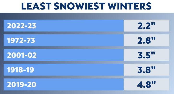
The record for the least snowiest winter in the 155 years of climate records for New York City was the winter of 1972-73. That winter brought just under 3 inches of snow. The average snowfall in a typical New York City winter is near 30 inches.
I started to think we had a shot at breaking the record.
In late February, our warm weather pattern shifted. It turned colder, and we saw a series of storm threats. We saw snow, but not much of it stuck. Despite having three days with measurable snow in February, our total by the start of March was just 2.2 inches.
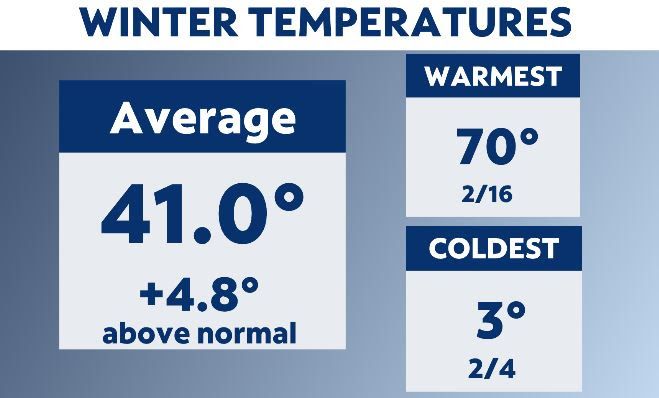
The reasons for the lack of snow have to do with temperatures. February was the second warmest on record, while January was the warmest ever. You just can't get snow when it's that warm.
The lack of storms also helped us to set the record. February, which is often our snowiest month, was dry with less than two inches of precipitation.
The weather pattern this winter was more influenced by La Niña than by climate change. Climate change is making our winters warmer, but this is measured in decades and not just in one season.
In fact, since the year 2000, we've seen nine years rank in the top 10 hottest on record for NYC, but NYC also had many snowy winters. This is because climate change produces stronger and wetter storms. Three of the five greatest snowfalls in our city have happened in the last 17 years.
In the past two decades, we've seen fewer snow events, but the ones we get are strong. La Niña, which is a cyclical warming of the Pacific Ocean off of Chile, helped create a jet stream pattern that battered the West Coast while making for mild conditions in the East.
Does an easy winter mean a hot summer? There's no direct relation between winter and summer seasons. As for next winter, it's impossible to know, but the odds are very high that we'll see more snow than this year.
Our team of meteorologists dives deep into the science of weather and breaks down timely weather data and information. To view more weather and climate stories, check out our weather blogs section.