


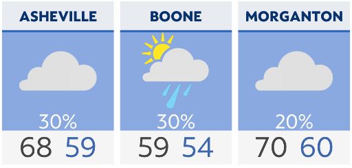
A severe weather threat will will work east through the day. The main threats are damaging wind gusts, large hail, isolated tornadoes and localized flooding. Storms could fire up in the wake of the main squall line. If we clear quickly enough and the atmosphere can rebound, those storms could become strong to severe during late afternoon and evening. It'll be breezy through the day with wind gusts up to 40 mph.
A cooler air mass settles in overnight and briefly sticks around Monday. A few flurries can't be ruled out for the northwest-facing slopes through daybreak. Temperatures will warm to 10-15 degrees above average by Tuesday and Wednesday.
Another front moves in Thursday, but this system will lack moisture and instability.
Check radar and the latest 7-day forecast | Share your weather photos